


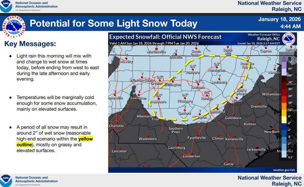
JOHNSTON COUNTY – Rain falling across Johnston County on Sunday is expected to mix with or briefly change to snow before ending this evening.
According to the National Weather Service office in Raleigh, a narrow band of light snow is forecast to set up across portions of the northern Piedmont, including areas north and west of Raleigh, where accumulations around a half-inch are most likely. Johnston County lies near the southern edge of that band, where little to no accumulation is expected.
Rain will mix with snow during the morning hours, with precipitation changing to primarily snow from west to east after 10 a.m. before ending by around 7 p.m., forecasters said.
Any snow that does fall in Johnston County is expected to be brief and light — generally a dusting to a half-inch — with accumulation mainly limited to grassy areas and elevated surfaces such as bridges and overpasses. Higher snow totals shown on the forecast map are expected farther north and west.
While snowfall impacts locally are expected to be minimal, colder temperatures Sunday night could create hazardous travel conditions. As temperatures fall below freezing, lingering water from earlier rainfall may refreeze, leading to patchy black ice on roads, sidewalks and parking lots overnight into Monday morning.
Black ice is possible anywhere across central North Carolina, particularly in areas that received heavier rainfall. Temperatures are expected to rise above freezing by about 10 a.m. Monday, reducing the ice threat.
Another surge of Arctic air is expected early next week, with wind chill values dropping into the teens and lower 20s Tuesday and Wednesday mornings.
Subscribe to get the latest posts sent to your email.