
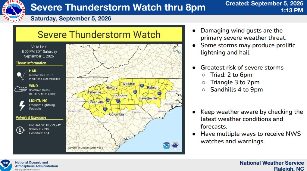
SMITHFIELD, N.C. – Johnston County is under a Severe Thunderstorm Watch until 8 p.m. Saturday, Sept. 5, with damaging wind gusts considered the primary severe-weather threat.
The National Weather Service Storm Prediction Center issued the Severe Thunderstorm Watch for a large portion of North Carolina, including Johnston County and much of the Triangle, Piedmont, Sandhills and western portions of the state.
Forecasters said scattered wind gusts of up to 70 mph are possible, along with isolated hail up to ping-pong ball size and frequent lightning.
The National Weather Service Raleigh office said the greatest risk of severe storms in the Triangle is expected between approximately 3 and 7 p.m.
Some storms could produce prolific lightning and hail in addition to damaging winds.
A Severe Thunderstorm Watch means conditions are favorable for severe thunderstorms to develop. It does not mean severe weather is occurring everywhere in the watch area. A Severe Thunderstorm Warning would be issued if a severe storm is detected or imminent for a specific location.
The watch includes 63 North Carolina counties:
Alamance, Alexander, Anson, Avery, Buncombe, Burke, Cabarrus, Caldwell, Caswell, Catawba, Chatham, Cleveland, Cumberland, Davidson, Davie, Durham, Edgecombe, Forsyth, Franklin, Gaston, Granville, Guilford, Halifax, Harnett, Haywood, Henderson, Hoke, Iredell, Jackson, Johnston, Lee, Lincoln, Madison, McDowell, Mecklenburg, Mitchell, Montgomery, Moore, Nash, Orange, Person, Polk, Randolph, Richmond, Rockingham, Rowan, Rutherford, Sampson, Scotland, Stanly, Stokes, Surry, Swain, Transylvania, Union, Vance, Wake, Warren, Wayne, Wilkes, Wilson, Yadkin and Yancey.
Damaging straight-line winds can bring down trees and power lines and cause property damage. Anyone placed under a Severe Thunderstorm Warning should move indoors and stay away from windows until the storm passes.
Subscribe to get the latest posts sent to your email.